This Page Contains Details of all Cists within Map Square 56
Wigford Down OSGR SX 5438 6443
Comments
"Near by, to the north [of Wigford Down S, 5442 6442], stand two more circles, in one of which are what may be the
remains of another kistvaen." Not found near the above grid reference. This probably refers to the cairns on the summit, at 5471 6494.
References
TPI X (1890) 294.
Barrow Report 12, T.D.A. Vol.22 p50 (1890)
Phil Newman Southwest Landscape Investigations p9
HER/SMR number 2373.
NMR number 439547 SX 56 SW 10.
Wigford Down S. OSGR SX 54420 64426
Comments
All four slabs present. Capstone to S.
References
TPI X (1890) 294.
Barrow Report 12, T.D.A. Vol.22 pp. 49. 19,
TDA XXXII (1900) 48.
Davidson & Seabrook DASP 31 (1973) 82.
L.V. Grinsell DASP 36 (1978) Meavy 7.
J.R. Turner DASP 48 (1990) E6.
J. Butler Atlas of Antiquities III (1994) 48.1.1.
Dave Parks cist 1:- cists, cist table, & cairn circles.
HER/SMR number 2373 SX 56 SW/6.
NMR number 439547 SX 56 SW 10
Plans of the site can be found in TDA XXXII (1900) Plate II, and Butler III (1994) p80.
A photograph of the site can be found in TDA XXXII (1900) Plate II.
Wigford Down Summit OSGR SX 5471 6494
Comments
Davidson and Seabrook incorrectly identify the site, which was in any case incorrectly reported by RH Worth (See TDA XXXIII 1901 p 121).
The identifying feature is the stone 9' by 4' by 1'.
References
Barrow Report 12, T.D.A. Vol.22 pp. 50. 20 (1890), TDA XXXIII (1901) p121. 62, TDA LXXV (1943) 54-5.
Davidson & Seabrook DASP 31 (1973) 74C (Not 74A).
L.V. Grinsell DASP 36 (1978) Meavy 7b.
J. Butler Atlas of Antiquities III (1994) 48.1.5.
Dave Parks cairn circles.
HER/SMR number 2367.
NMR number 439543 SX 56 SW 6.
A plan of the site can be found in Butler III (1994) p97.
A map of the area can be found in Butler III (1994) p79.
A photograph of the site can be found in TDA LXXV (1943) Pl 10.
Wigford Down 7 OSGR SX 5496 6508
Comments
Davidson & Seabrook claim a cist here, presumably in the ring cairn, but Worth gives no support for the claim in his barrow report.
References
Barrow Report 12, T.D.A. Vol.22 pp.50. Barrow Report 19, T.D.A. Vol.32 p 48 (1900).
R.H. Worth Dartmoor (1953) p172.
Davidson & Seabrook DASP 31 (1973) 74D
L.V. Grinsell DASP 36 (1978) Meavy 4a.
J.R. Turner DASP 48 (1990) A42.
J. Butler Atlas of Antiquities III (1994) 48.1.7.
HER/SMR number 2310 SX 56 NW/10.
NMR number 439081 SX 56 NW 23.
A map of the area can be found in Butler II (1991) p79.
Burrator
Burrator OSGR SX 55729 69487
Comments
Found before 2021 by the Burrator Discovery Centre while clearing the nearby pound MDV 20613 at SX 556 694. A circle of stones, with four stones flush to the ground, and a captone levered up and wedged in place.
Not in HER as of 2 May 2022.
Burrator OSGR SX 55729 69487
Comments
Found before 2021 by the Burrator Discovery Centre while clearing the nearby pound MDV 20613 at SX 556 694. A circle of stones, with four stones flush to the ground, and a captone levered up and wedged in place.
Not in HER as of 2 May 2022.
Collard Tor OSGR SX 5585 6204
Comments
A stone row descends towards the south.
Butler p 109 states: "A slab lying on the edge of the central pit may be ... the cover of a cist."
References
Barrow Report 22, TDA XXXV (1903) 140.
TDA LXXVIII (1946) p291.
Davidson & Seabrook DASP 31 (1973) 24.
L.V. Grinsell DASP 36 (1978) Shaugh Prior 46.
J.R. Turner DASP 48 (1990) F17.
J. Butler Atlas of Antiquities III (1994) 48.6.1.
HER/SMR number 14793 SX 56 SE/174 or /230.
NMR number 439259 SX 56 SE 53
A plan of the site can be found in Butler III (1994) p108.
A map of the area can be found in TDA XXXV (1903) p141.
Cross Gate OSGR SX 5631 6953
Comments
Two side stones and NW endstone remain, with possible SE endstone.
Possible coverstone displaced to SW.
References
Barrow Report 54, TDA LXVII (1935) 77.
R.H.Worth Dartmoor (1953) p172.
Davidson & Seabrook DASP 31 (1973) 57
L.V. Grinsell DASP 36 (1978) 175, Walkhampton 25.
J.R. Turner DASP 48 (1990) E20.
J. Butler Atlas of Antiquities III (1994) 45.17.
G.A.M. Gerrard Dartmoor (1997) 56.
Dave Parks cist 61:- cists, cist table, & Dave Parks cairn circles (Lether Tor).
Megalithic Portal
HER/SMR number 3434 SX 56 NE/130
NMR number 438516 SX 56 NE 8
Plans of the site can be found in TDA LXVII (1935) Pl III, Butler III (1994) p52, and Gerrard (1997) Fig 33, p56.
Photograph(s) of the site can be found in TDA LXVII (1935) Pl III
Ringmoor Down OSGR SX 5659 6668
Comments
There are remains of a retaining circle consisting of five stones, all standing, visible in SW quadrant. Dia 13m, ht 0.5m.
Secondary cist and retaining kerb exposed.
References
HER/SMR number 3994 SX 56 NE/15.
NMR number 438665 SX 56 NE 58.
Comments
There are remains of a retaining circle consisting of five stones, all standing, visible in SW quadrant. Dia 13m, ht 0.5m.
Secondary cist and retaining kerb exposed.
References
HER/SMR number 3994 SX 56 NE/15.
NMR number 438665 SX 56 NE 58.
Legis Lake OSGR SX 5660 6576
Comments
All four stones in place, with displaced coverstone.
References
Barrow Report 49 TDA XLII (1910) 62, Barrow Report 31 TDA XLIV (1912) 83.
H. Breton Beautiful Dartmoor (1911) 52.
R.H. Worth Dartmoor (1953) p169, 172.
Davidson & Seabrook DASP 31 (1973) 27B.
P. Pettit Prehistoric Dartmoor (1974) 114.
L.V. Grinsell DASP 36 (1978) Sheepstor 20.
J.R. Turner DASP 48 (1990) E32.
J. Butler Atlas of Antiquities III (1994) 49.21.2.
Dave Parks cist 27:- cists, cist table, & cairn circles.
HER/SMR number 4030 SX 56 NE/35.
NMR number 438677 SX 56 NE 62.
Plans of the site can be found in TDA XLII (1910) p62, RH Worth Dartmoor (1953) p169 and Butler III p145.
A ma of the area can be found in Butler III, p144.
Photographs of the site can be found in TDA XLII (1910) p62, RH Worth Dartmoor (1953) p169 and Pettit, p89.
Trowlesworthy Warren OSGR SX 5715 6475
Comments
E stone missing, capstone to W.
References
L.V. Grinsell DASP 36 (1978) Shaugh Prior 30a.
J.R. Turner DASP 48 (1990) E40.
J. Butler Atlas of Antiquities III (1994) 51.1.
Dave Parks cist 112:- cists, cist table, cairn circles.
HER/SMR number 28570 SX 56 SE/340.
NMR number 439438 SX 56 SE 117.
A plan of the site can be found in Butler III (1994) p158.
Legis Tor W. OSGR SX 57394 65484
Comments
The coverstone, to the S, is 5' by 4'1". In addition, two side stones remain.
References
Barrow Report 12, TDA TPI XXII (1890) p50. Barrow Report 20, TDA XXXIII (1901) 118, Barrow Report 51 TDA LXIV (1932) p119.
R.H. Worth Dartmoor (1953) p171, 172.
L.V. Grinsell DASP 36 (1978) Sheepstor 22.
J.R. Turner DASP 48 (1990) E43.
J. Butler Atlas of Antiquities III (1994) 49.2.2.
Dave Parks cist 10:- cists, cist table, & cairn circles.
Megalithic Portal
HER/SMR number 3365 SX 56 NE/70.
NMR number 438692 SX 56 NE 67.
Plans of the site can be found in TDA XXII (1901) Pl XII, and Butler III (1994) p114.
A photograph(s) of the site can be found in TDA LXIV (1932) Pl III
Legis Tor E. OSGR SX 5747 6553
Comments
One side and one end stone in place, and one side fallen. Other endstone possibly to W, and the capstone is missing.
Brian Byng (pers. comm.) 57487 65542.
References
Barrow Report 51, TDA LXIV (1932) 117.
R.H. Worth Dartmoor (1953) p172.
Davidson & Seabrook DASP 31 (1973) 58.
L.V. Grinsell DASP 36 (1978) Sheepstor 23.
J.R. Turner DASP 48 (1990) E42.
J. Butler Atlas of Antiquities III (1994) 49.2.1.
Dave Parks cist 49:- cists, cist table, & cairn circles.
Megalithic Portal
HER/SMR number 3424 SX 56 NE/120.
NMR number 438689 SX 56 NE 66.
Plans of the site can be found in TDA LXIV (1932), Pl II, and Butler III (1994) p113.
A photograph of the site can be found in TDA LXIV (1932), Pl II.
Gutter Tor Summit OSGR SX 5760 6683
Comments
Only two end and one side slab remain. Grinsell mentions coverstone to E.
Brian Byng (pers. comm.) 57606 66819.
References
Barrow Report 19, TDA XXXII (1900) 48.
R.H. Worth Dartmoor (1953) p172.
L.V. Grinsell DASP 36 (1978) Sheepstor 15.
J. Butler Atlas of Antiquities III (1994) 49.5.2.
Dave Parks cist 2:- cists, & cist table.
HER/SMR number 3991 SX 56 NE/12.
NMR number 438659 SX 56 NE 56.
Plans of the site can be found in TDA XXXII (1900) Pl III, and Butler III (1994) 118.
A photograph of the site can be found in TDA XXXII (1900) Pl III.
Gutter Tor N. OSGR SX 5767 6712
Comments
All four slabs present, though N end slab fallen in. Possibly originally 0.84m long.
References
Barrow Report 59, TDA LXXII (1940) 63.
R.H. Worth Dartmoor (1953) p172.
Davidson & Seabrook DASP 31 (1973) 66
L.V. Grinsell DASP 36 (1978) Sheepstor 9
J.R. Turner DASP 48 (1990) E38
J. Butler Atlas of Antiquities III (1994) 49.5.3
Dave Parks cist 86:- cists, cist table, & cairn circles.
HER/SMR number 4045 SX 56 NE/144/1
NMR number 438610 SX 56 NE 39
Plans of the site can be found in TDA LXXII (1940) p63, and Butler III (1994) p118.
A photograph of the site can be found in TDA LXXII (1940) Pl I
Outcombe OSGR SX 5797 6826
Comments
Three sides still stand, but the E side and coverstone are missing. Very nearly square.
Brian Byng (pers. comm.) 57992 68280.
References
Barrow Report 52, TDA LXV (1933) 85.
R.H. Worth Dartmoor (1953) p172.
L.V. Grinsell DASP 36 (1978) Sheepstor 2.
J. Butler Atlas of Antiquities III (1994) 47.10.
Dave Parks cist 54:- cists, & cist table.
HER/SMR number 4024 SX 56 NE/28.
NMR number 438592 SX 56 NE 32.
Plans of the site can be found in TDA LXV (1933) Pl X, and Butler III (1994) p70.
A photograph of the site can be found in TDA LXV (1933) Pl X.
Down Tor S. OSGR SX 5803 6928
Comments
The coverstone lies to the S. W end slab missing.
References
Barrow Report 67, TDA LXXX (1948) 37.
R.H. Worth Dartmoor (1953) p172.
L.V. Grinsell DASP 36 (1978) Walkhampton 26.
J. Butler Atlas of Antiquities III (1994) 47.5.
Dave Parks cist 93:- cists, & cist table.
HER/SMR number 3423 SX 56 SE/175 (sic).
NMR number 438538 SX 56 NE 14.
Plans of the site can be found in TDA LXXX (1948) Pl I, and Butler III (1994) p67.
A photograph of the site can be found in TDA LXXX (1948) Pl I
Sheepstor Brook OSGR SX 5820 6742
Comments
A possible endslab, noticed by WJR 19/5/2002
References
HER/SMR number 22766
NMR number 619139 SX 56 NE 201.
Comments
A possible endslab, noticed by WJR 19/5/2002
References
HER/SMR number 22766
NMR number 619139 SX 56 NE 201.
Willings Walls Warren S. OSGR SX 5827 6522
Comments
All four stones and coverstone present.
References
Barrow Report 51, TDA LXIV (1932) 115.
TDA IV (ii) (1871) 513, XXXVII (1905) 458.
TPI XI Part II (1892) p174
R.H. Worth Dartmoor (1953) p172, 174.
L.V. Grinsell DASP 36 (1978) Shaugh Prior 25.
J.R. Turner DASP 48 (1990) E36.
J. Butler Atlas of Antiquities III (1994) 51.6.
Dave Parks cist 48:- cists, cist table, & cairn circles.
HER/SMR number 4021 SX 56 NE/24.
NMR number 438714 SX 56 NE 75.
Plan of the site can be found in TDA LXIV p116 & Pl I, and Butler III (1994) p165.
A photograph of the site can be found in TDA LXIV (1932) Pl I.
Willings Walls Warren OSGR SX 5828 6533
Comments
"A few yards N of the wall & about 100yds W of Hen Tor brook." All stones present, but the capstone lies a few ft off to the NW. SMR also give grid reference 585 656, SX 56 NE/358. MR SX 56 NE/157 & NMR SX 56 NE/74 give false grid reference 5815 6559.
References
Barrow Report 12, XXII (1890) 52. 14, TDA XXIV (1892) 48. 19, TDA XXXII (1900) 49.
H. Breton Beautiful Dartmoor I (1911) 49.
R.H. Worth Dartmoor (1953) p172.
Davidson & Seabrook DASP 31 (1973) 72B.
L.V. Grinsell DASP 36 (1978) Shaugh Prior 24.
J. Butler Atlas of Antiquities III (1994) 51.6.
Dave Parks cist 3:- cists, & cist table.
HER/SMR number 4022 SX 56 NE/25.
NMR number 438717 SX 56 NE 76.
Plans of the site can be found in TDA XXXII (1900) Pl IV, and Butler III (1994) p166.
A photograph of the site can be found in TDA XXXII (1900) Pl IV.
Ditsworthy Circle OSGR SX 5837 6570
Comments
"Formerly enclosed two kistvaens, the cover stones of which are still among the ruins."
Not now visible. Grinsell suggests this is the same as Sheepstor 34.
References
H. Breton Beautiful Dartmoor (1911) 49.
L.V. Grinsell DASP 36 (1978) Sheepstor 36.
J. Butler Atlas of Antiquities III (1994) 49.6.
Dave Parks cist 141:- cists, cist table, cairn circles.
HER/SMR number 42211 SX 56 NE/500.
NMR number 438980 SX 56 NE 170.
Down Tor N 2 OSGR SX 5837 6955
Comments
SMR has LVG's approximate grid reference, except on the first page of the record.
Complete except for capstone.
References
Barrow Report 73, TDA XC (1958) 230.
L.V. Grinsell DASP 36 (1978) Walkhampton 27.
J. Butler Atlas of Antiquities III (1994) 47.13.2.
Dave Parks cist 107:- cists, cist table, & cairn circles.
HER/SMR number 3498 & 12715 SX 56 NE/174/2.
NMR number 438861 SX 56 NE 127.
A plan of the site can be found in TDA XC (1958) p231
A map of the area can be found in Butler III (1994) p73.
A photograph of the site can be found in TDA XC (1958) fig 42.
Down Tor N 1 OSGR SX 5838 6956
Comments
SMR has LVG's approximate grid reference, except on the first page of the record.
Smallest known cist. One end and capstone missing.
References
Barrow Report 73, TDA XC (1958) 230.
L.V. Grinsell DASP 36 (1978) Walkhampton 28.
J. Butler Atlas of Antiquities III (1994) 47.13.1.
Dave Parks cist 108:- cists, & cist table.
HER/SMR number 3498 & 12715 SX 56 NE/174/1.
NMR number 438861 SX 56 NE 127.
A plan of the site can be found in TDA XC (1958) p232
A map of the area can be found in Butler III (1994) p73.
A photograph of the site can be found in TDA XC (1958) fig 43.
Down Tor N 3 OSGR SX 5839 6955
Comments
SMR has LVG's approximate grid reference, except on the first page of the record.
Both sides and both end stones (one longer due to additional stone) present but no capstone.
References
Barrow Report 73, TDA XC (1958) 230.
L.V. Grinsell DASP 36 (1978) Walkhampton 29.
J.R. Turner DASP 48 (1990) E34.
J. Butler Atlas of Antiquities III (1994) 47.13.3.
Dave Parks cist 109:- cists, & cist table.
HER/SMR number 3499 & 12715 SX 56 NE/174/3.
NMR number 438861 SX 56 NE 127.
A plan of the site can be found in TDA XC (1958) p233.
A map of the area can be found in Butler III (1994) p73.
A photograph of the site can be found in TDA XC (1958) fig 44.
Lee Moor OSGR SX 5854 6445
Comments
All four sides in place, but no capstone. Cist placed slightly E of centre of the mound.
References
Barrow Report 63, TDA LXXVI (1944) 39.
R.H. Worth Dartmoor (1953) p172.
Davidson & Seabrook DASP 31 (1973) 60
L.V. Grinsell DASP 36 (1978) Shaugh Prior 31.
J. Butler Atlas of Antiquities III (1994) 51.5.3.
G.A.M. Gerrard Dartmoor (1997) 56.
Dave Parks cist 89:- cists, & cist table.
HER/SMR number 2495 or 42010 SX 56 SE/65.
NMR number 439118 SX 56 SE 5.
Plans of the site can be found in TDA LXXVI (1944) Pl 2, Butler III (1994) p164, and Gerrard (1997) Fig 33, p56.
A map of the area can be found in Butler III (1994) p163.
A photograph of the site can be found in TDA LXXVI (1944) Pl 2.
Lee Moor S2 OSGR SX 5855 6434
Comments
This cairn with a cist lies on a W facing slope. The cist is situated immediately E of large boulder. All sides present, N & S sides at an angle. Capstone missing. 1.3m long, 1m wide, 0.4 m deep. Traces of kerbstone.
References
L.V. Grinsell DASP 36 (1978) Shaugh Prior 34.
J. Butler Atlas of Antiquities III (1994) 51.5.2.
HER/SMR number 2418 SX 56 SE/22.
NMR number 439121 SX 56 SE 6.
Lee Moor S1 OSGR SX 5858 6433
Comments
This cairn with a cist lies on a W facing slope. The cist has both end and side stones, rather
irregularly positioned. 0.8m long, 0.6m wide, 0.3m deep. Coverstone missing.
References
L.V. Grinsell DASP 36,(1978) Shaugh Prior 35.
J. Butler Atlas of Antiquities III (1994) 51.5.1.
HER/SMR number 42216 SX 56 SE/395.
NMR number 439121 SX 56 SE 6.
Lee Moor E. OSGR SX 5859 6447
Comments
".. may have held a cist as the edge of a narrow slab is visible near the centre."
References
L.V. Grinsell DASP 36 (1978) Shaugh Prior 33
J. Butler Atlas of Antiquities III (1994) 51.5.5
HER/SMR number 12786
NMR number 439522 SX 56 SE 145.
Comments
".. may have held a cist as the edge of a narrow slab is visible near the centre."
References
L.V. Grinsell DASP 36 (1978) Shaugh Prior 33
J. Butler Atlas of Antiquities III (1994) 51.5.5
HER/SMR number 12786
NMR number 439522 SX 56 SE 145.
Eylesburrow W. OSGR SX 5868 6784
Comments
Restored before 1929. At least one endstone and a side made from two stones. Leaning coverstone.
Cist offset from centre of cairn.
Brian Byng (pers. comm.) 58696 67849.
References
Barrow Report 48, TDA LXI (1929) 85.
R.H. Worth Dartmoor (1953) p172.
Davidson & Seabrook DASP 31 (1973) 56.
L.V. Grinsell DASP 36 (1978) Sheepstor 7.
J. Butler Atlas of Antiquities III (1994) 47.11.
Dave Parks cist 45:- cists, & cist table.
HER/SMR number 3341 SX 56 NE/51.
NMR number 438574 SX 56 NE 26.
A plan of the site can be found in Butler III (1994) p70.
A photograph of the site can be found in TDA LXI (1929) p85.
Down Tor Cairn Circle OSGR SX 5868 6926
Comments
"Formerly enclosed a large kistvaen", according to Breton. Not now visible.
Butler notes two large slabs in the centre.
Bate, in originally reporting the site, mislocated the site.
References
Brent British Arahceological Association Vol 39 1883
Barrow Report 14, TDA XXIV (1892) 48.
TDA TDA IV ii (1871) 505-6.
W.C. Lukis Proc Soc Antiq Lond VIII (2nd Series) (1881) 474-5.
H. Breton Beautiful Dartmoor (1912) 41-2.
Davidson & Seabrook DASP 31 (1973) 33
L.V. Grinsell DASP 36 (1978) Walkhampton 31
J.R. Turner DASP 48 (1990) F6
J. Butler Atlas of Antiquities III (1994) 47.12.
P. Newman The Field Archaeology of Dartmoor (2011) 45.
Dave Parks cairn circles (Hingston Hill).
HER/SMR number 3439 SX 56 NE/177
NMR number 438583 SX 56 NE 29
Plans of the site can be found in Butler III (1994) p72, & Newman (2011) p45.
Photographs of the site can be found in Falcon 1900, 61, & Newman (2011) p45.
Hen Tor Meadow W. OSGR SX 5892 6578
Comments
NMR & SMR ref is from Breton - "A cist within a double circle of fallen stones" Breton is known to be inaccurate. Not found by OS in 1979 - the area is marshy. Possibly the same as SMR SX 56 NE/24, NMR SX 56 NE 75?
References
HER/SMR number 3504 SX 56 NE/179.
NMR number 438729 SX 56 NE 80. The information is from Breton OS 6" map collection 1950.
A Breton Special OSGR SX 59 66
Comments
Could be any one of the cists in the area. The information is from Breton in OS map collection.
NMR suggest SX 56 NE 44, 5909 6577? Possibly the 5947 6674 site?
References
NMR Number 438803 SX 56 NE 106
Comments
Could be any one of the cists in the area. The information is from Breton in OS map collection.
NMR suggest SX 56 NE 44, 5909 6577? Possibly the 5947 6674 site?
References
NMR Number 438803 SX 56 NE 106
Drizzlecombe SW. OSGR SX 5903 6671
Comments
Grinsell suggests this is the site referred to by Breton as Ditsworthy Circle, Sheepstor 36.
Brian Byng (pers. comm.) 59021 66719.
References
S. Rowe TPI X (1890) 289-310.
Barrow Report 12,TDA XXII (1890) 52. 19, TDA XXXII (1900) 49.
R.H. Worth Dartmoor (1953) p172, 193, 196.
L.V. Grinsell DASP 36 (1978) Sheepstor 34.
J. Butler Atlas of Antiquities III (1994) 49.19.22.
Dave Parks cist 4:- cists, cist table, ceremomial complexes, & sites.
Megalithic Portal
HER/SMR number 3340 SX 56 NE/50.
NMR number 438635 SX 56 NE 48.
Plans of the site can be found in TDA XXXII (1890) Pl V, and Butler III (1994) p141.
Maps of the area can be found in RH Worth Dartmoor (1953) p211, DASP 36 (1978) Fig 3, and Butler III (1994) p135.
A photograph of the site can be found in TDA XXXII (1900) Pl V
A drawing of some pottery found in the cist can be found in BR19, Plate I, and RH Worth Dartmoor (1953) p199.
Hen Tor Meadow OSGR SX 5909 6577
Comments
Grinsell gives references 591 664 & 5909 6583, & says it is "near junction of Shavercombe Lake & river Plym"! All four slabs,
but no coverstone.
References
L.V. Grinsell DASP 36 (1978) Shaugh Prior 48.
J.R. Turner DASP 48 (1990) E45.
Dave Parks cist 114:- cists, cist table, & cairn circles.
HER/SMR number 12744 SX 56 NE/229.
NMR number 439036 SX 56 NE 190, but maybe also 438803 SX 56 NE 106?
A map of the area can be found in DASP 36 (1978) Fig 3
Hemery's Rows OSGR SX 591 693
Comments
A much overgrown single row, of only 9 stones, leading to the probable remains of a kistvaen,
and yet another single row, fallen and overgrown leading NE to another cairn.
References
HER/SMR number 56216 SX 56 NE/98
NMR number 619145 SX 56 NE 204
Comments
A much overgrown single row, of only 9 stones, leading to the probable remains of a kistvaen,
and yet another single row, fallen and overgrown leading NE to another cairn.
References
HER/SMR number 56216 SX 56 NE/98
NMR number 619145 SX 56 NE 204
Drizzlecombe N 14 OSGR SX 5912 6712
Comments
BR 12 says the cairn circle "probably contains an unopened kist", but there is mention only of an interment pit
in the excavation report in BR 34.
References
Barrow Reports 12, TDA XXII (1890) 50, & 34, TDA XLVII (1915) 131.
TDA LXXVIII (1946) Pl 35.
R.H. Worth Dartmoor (1953) 211.
L.V. Grinsell DASP 36 (1978) Sheepstor 25a.
J. Butler Atlas of Antiquities III (1994) 49.19.14.
P. Newman The Field Archaeology of Dartmoor (2011) 40.
Dave Parks cairn circles, ceremomial complexes, & sites.
HER/SMR number 3374 SX 56 NE/78.
NMR number 438613 SX 56 NE 40.
A plan of the site can be found in Butler III (1994) p141.
Maps of the area can be found in TDA LXVIII (1946) Plate 35 & RH Worth Dartmoor (1953) p211 (where it is wrongly placed),
DASP 36 (1978) Fig 3, Butler III (1994) p135, & Newman (2011) p40.
A photograph of the site can be found in TDA XLVII (1915) p131.
Drizzlecombe OSGR SX 5925 6695
Comments
In BR 12, RHW says there are a pair of parallel stones to the E of Giants Basin.
References
Barrow Report 12, TPI XXII (1890) 51, 52.
Dave Parks ceremomial complexes, & sites.
HER/SMR number 3372 3372.
NMR number 438883 SX 56 NE 137.
Comments
In BR 12, RHW says there are a pair of parallel stones to the E of Giants Basin.
References
Barrow Report 12, TPI XXII (1890) 51, 52.
Dave Parks ceremomial complexes, & sites.
HER/SMR number 3372 3372.
NMR number 438883 SX 56 NE 137.
Drizzlecombe N 13 OSGR SX 5915 6721
Comments
All four side slabs in place, with coverstone propped up to NW.
BR 12, but not 19, refers to a stone row leading to the cairn circle at 5912 6712.
Brian Byng (pers. comm.) 59158 67198.
References
Barrow Report 12, TPI XXII (1890) 50, 51. 19, TDA XXXII (1900) 49-50.
J. Chudleigh An Exploration of Dartmoor's Antiquities (1892) p94-5.
R.H. Worth Dartmoor (1953) p172.
Davidson & Seabrook DASP 31 (1973) 32.
L.V. Grinsell DASP 36 (1978) Sheepstor 25.
J. Butler Atlas of Antiquities III (1994) 49.19.13.
G.A.M. Gerrard Dartmoor (1997) 56.
P. Rainbird A Guide to the Archaeology of South Devon (2010) 21-23.
P. Newman The Field Archaeology of Dartmoor (2011) 40.
Dave Parks cist 5:- cists, cist table, ceremomial complexes, & sites.
Megalithic Portal
HER/SMR number 3339 SX 56 NE/49.
NMR number 438565 SX 56 NE 23.
Plans of the site can be found in TDA XXXII (1900) Pl VI, Butler III (1994), & Gerrard (1997) Fig 33, p56.
Maps of the area can be found in RH Worth Dartmoor (1953) p211, DASP 36 (1978) Fig 3, Butler III (1994) p135, Rainbird (2010) p20,
& Newman (2011) p40.
Photographs of the site can be found in TDA XXXII (1900) Pl VI, & LXIX (1937), p75, and Rainbird p21.
Drizzlecombe SW Row OSGR SX 5917 6696
Comments
Barrow at head of row. BR 12 says "A stone, probably the cover of this kistvaen, lies a few feet away to the south."
Butler says this stone is the first of the stone row.
References
Barrow Report 12, TPI XXII (1890) 50.
TDA XXIV (1892) 400.
L.V. Grinsell DASP 36 (1978) Sheepstor 32.
J. Butler Atlas of Antiquities III (1994) 49.19.1.
P. Newman The Field Archaeology of Dartmoor (2011) 40.
Dave Parks ceremomial complexes, & sites.
HER/SMR number 14777
NMR number 438629 SX 56 NE 46.
A plan of the site can be found in Butler III (1994) p137.
Maps of the area can be found in TDA LXXVIII (1946) Pl 35, DASP 36 (1978) Fig 3, Butler III (1994) p135-6, & Newman (2011) p40.
Giants Basin Foot OSGR SX 5919 6694
Comments
Possibly natural.
References
S. Rowe TPI (1890).
Barrow Report 12, TDA XXII (1890) 51.
H. Breton Beautiful Dartmoor I (1911) 45.
L.V. Grinsell DASP 36 (1978) Sheepstor 33d.
J. Butler Atlas of Antiquities III (1994) 49.19.6.
HER/SMR number 3373 SX 56 NE/77/1.
NMR number 438623 SX 56 NE 44.
A map of the area can be found in DASP 36 (1978) Fig 3
Narrator Brookhead N. OSGR SX 5920 6945
Comments
The large cairn to NW of Down Tor (Hingston Hill) stone row has been claimed to contain a cist or
"elements of chambering".
References
W.C. Lukis Proc Soc Antiq Lond VIII (2nd Series) (1881) 474.
F. Brent J Brit Arch Assoc 39 (1883) 219.R. Burnard Dartmoor Pictorial Records IV (1894) 69.
L.V. Grinsell DASP 36 (1978) Walkhampton 32, p175.
J. Butler Dartmoor Atlas of Antiquities III (1994) 47.7.1 p68.
HER/SMR number 3375
NMR number 438589 SX 56 NE 31
Comments
The large cairn to NW of Down Tor (Hingston Hill) stone row has been claimed to contain a cist or
"elements of chambering".
References
W.C. Lukis Proc Soc Antiq Lond VIII (2nd Series) (1881) 474.
F. Brent J Brit Arch Assoc 39 (1883) 219.
L.V. Grinsell DASP 36 (1978) Walkhampton 32, p175.
J. Butler Dartmoor Atlas of Antiquities III (1994) 47.7.1 p68.
HER/SMR number 3375
NMR number 438589 SX 56 NE 31
Drizzlecombe N. OSGR SX 5922 6747
Comments
All four slabs in place, but no cover.
References
Barrow Report 26, TDA XXXIX (1907) 83. 34, TDA XLVII (1915) 131.
R.H. Worth Dartmoor (1953) p172.
L.V. Grinsell DASP 36 (1978) Sheepstor 24.
J. Butler Atlas of Antiquities III (1994) 49.19.21.
Dave Parks cist 21:- cists, cist table, ceremomial complexes, & sites.
HER/SMR number 3363 SX 56 NE/68.
NMR number 438532 SX 56 NE 12.
Plans of the site can be found in TDA XXXIX (1907) p83, and Butler III (1994) p141.
Maps of the area can be found in DASP 36 (1978) Fig 3, and Butler III (1994) p135.
A photograph of the site can be found in TDA XXXIX (1907) p83.
Drizzlecombe N Row OSGR SX 5924 6707
Comments
A depression in the centre may be the site of a cist - SMR. But this applies also to the other two cairns.
References
Barrow Report 12, TDA XXII (1890) p51.
L.V. Grinsell DASP 36 (1978) Sheepstor 29.
J. Butler Atlas of Antiquities III (1994) 49.19.3.
P. Newman The Field Archaeology of Dartmoor (2011) 40.
Dave Parks cairn circles, ceremomial complexes, & sites.
HER/SMR number 3329 SX 56 NE/80/2.
NMR number 438616 SX 56 NE 41.
A plan of the site can be found in Butler III (1994) p139.
Maps of the area can be found in TDA LXXVIII (1946), Pl 35, DASP 36 (1978), p109, Butler III (1994) p135, 136, & Newman (2011) p40.
Hen Tor Warren 1 OSGR SX 5925 6571
Comments
One side and one end stone visible, with other stones possibly present.
References
Butler III (1994) 49.22.1
Dave Parks cist 131:- cists, & cist table.
HER/SMR number 55317 SX 56 NE/586.
NMR number 438944 SX 56 NE 158.
A plan of the site can be found in Butler III (1994) p147.
A map of the area can be found in Butler III (1994) p147.
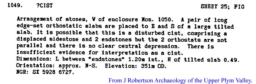
Drizzlecombe Settlement OSGR SX 5927 6727
Comments
Robertson, J. 1991 PhD Thesis Archaeology of the Upper Plym.
References
Dave Parks ceremomial complexes, & sites.
NMR number 1247712 SX 56 NE 239.
A map of the area can be found in Newman (2011) p40.
Comments
Robertson, J. 1991 PhD Thesis Archaeology of the Upper Plym.
References
Dave Parks ceremomial complexes, & sites.
NMR number 1247712 SX 56 NE 239.
A map of the area can be found in Newman (2011) p40.
Hen Tor Warren 2 OSGR SX 5936 6579
Comments
SW side slab missing, capstone to S. Not marked accurately on map in BR 52.
References
Barrow Report 20, TDA XXXIII (1901) 119.
R.H. Worth Dartmoor (1953) p172, 179.
Davidson & Seabrook DASP 31 (1973) 95.
L.V. Grinsell DASP 36 (1978) Shaugh Prior 26.
J.R. Turner DASP 48 (1990) E48.
J. Butler Atlas of Antiquities III (1994) 49.22.2.
Dave Parks cist 11:- cists, cist table, cairn circles.
HER/SMR number 3479 SX 56 NE/156.
NMR number 438785 SX 56 NE 100.
Plans of the site can be found in TDA XXXIII (1901), p118, and Butler III (1994) p147.
Maps of the area can be found in TDA LXV (1933). p83, DASP 36 (1978) Fig 3, and Butler III (1994) p147.
A photograph of the site can be found in TDA XXXIII (1901), p118
Narrator Brookhead S. OSGR SX 594 682
Comments
In tinworking area, near a whim platform.
References
HER/SMR number 66398
NMR number 1241864 SX 56 NE 229
Comments
In tinworking area, near a whim platform.
References
HER/SMR number 66398
NMR number 1241864 SX 56 NE 229
Penn Beacon 10 OSGR SX 5943 6264
Comments
"The upper edge of a narrow slab protuding through the turf near the centre is in the correct position for the endstone of a cist".
The plan in Butler V p25 (Fig 6) refers to Penn Beacon 5. The plan for this site is Fig 7, p26, showing the possible end stone of a cist.
References
Butler III (1994) p192-3 & V (1997), p4, 26.
HER/SMR number 12914.
A plan of the site can be found in Butler V (1997) p26
A map of the area can be found in Butler III (1994) p192.
Giants Hill OSGR SX 5947 6674
Comments
All four slabs in place, N endstone fallen in. No sign of coverstone.
Found by W.D. Lethbridge, who mentions another possible cist, under a stone, to the east.
References
G.A.M. Gerrard 1997 (Private communication).
W.D. Lethbridge One Man's Moor, Halsgrove (2006) 170.
HER/SMR numbers 70333 SX 56 NE/609 & SX 56 NE/616.
NMR number 1358033 SX 56 NE 302
Penn Beacon 1 OSGR SX 5951 6248
Comments
Within a cairn from which a short stone row begins was "... a not very perfect kist." Bate found a side stone, and other sides made from more than one stone. The capstone was to one side.
References
TDA V (1872) 549-52.
L.V. Grinsell DASP 36 (1978) Cornwood 3.
J. Butler Atlas of Antiquities III (1994) 52.14.1.
HER/SMR number 12909 SX 56 SE/2.
NMR number 439282 SX 56 SE 62.
Plans of the site can be found in TDA V (1872) p550 & Butler III (1994) p192.
A map of the area can be found in
Butler III (1994) p192.
Hen Tor Warren 3 OSGR SX 5957 6580
Comments
In perfect condition, except the coverstone is missing, although LVG & Butler say it has possibly been displaced downhill to the N.
References
Barrow Report 52, TDA LXV (1933) 84.
R.H. Worth Dartmoor (1953) p172, 179.
L.V. Grinsell DASP 36 (1978) Shaugh Prior 28.
J. Butler Atlas of Antiquities III (1994) 49.22.3.
Dave Parks cist 51:- cists, & cist table.
HER/SMR number 3490 SX 56 NE/167.
NMR number 438791 SX 56 NE 102.
A plan of the site can be found in TDA LXV (1933), Pl VII.
Maps of the area can be found in TDA XLV (1933), p83, DASP 36 (1978) Fig 3, and Butler III (1994) p147.
A photograph of the site can be found in TDA XLV (1933), Pl VII.
Penn Beacon 5 OSGR SX 5959 6247
Comments
The plan in Butler V p26 (Fig 7) refers to Penn Beacon 10. The plan for this site is Fig 6, p25, for which no cist is suggested.
References
Butler III (1994) p192-3 52.14.5 & V (1997), p24-5.
A plan of the site can be found in Butler V (1997) p25.
A map of the area can be found in Butler III (1994) p192.
Hen Tor Warren 6 OSGR SX 5960 6588
Comments
In good condition, but the capstone is missing. One side is markedly longer than the other.
References
Barrow Report 52, TDA LXV (1933) 84.
R.H. Worth Dartmoor (1953) p172, 176, 179.
P. Pettit Prehistoric Dartmoor (1974) 116.
L.V. Grinsell DASP 36 (1978) Shaugh Prior 27.
J.R. Turner DASP 48 (1990) D14.
J. Butler Atlas of Antiquities III (1994) 49.22.6.
Dave Parks cist 52:- cists, cist table, cairn circles.
HER/SMR number 3503 SX 56 NE/178.
NMR Number 438788 SX 56 NE 101.
Plans of the site can be found in TDA LXV (1933) Pl VIII, RH Worth Dartmoor (1953) p177, Pettit (1974) p115, & Butler III (1994) p147.
Maps of the area can be found in TDA XLV (1933), p83. DASP 36 (1978) Fig 3, Butler III (1994) p147.
A photograph of the site can be found in TDA LXV (1933) Pl VIII
Hen Tor Warren 4 OSGR SX 5964 6577
Comments
Two sides and one end stone present but NW endstone buried (according to Butler). Capstone levered off to E, and E side slab leaning out.
References
Barrow Report 12, TPI XXII (1890) 50. 20, TDA XXXIII (1901) 119.
R.H. Worth Dartmoor (1953) p172, 179.
Davidson & Seabrook DASP 31 (1973) 102.
L.V. Grinsell DASP 36 (1978) Shaugh Prior 29.
J.R. Turner DASP 48 (1990) E47.
J. Butler Atlas of Antiquities III (1994) 49.22.4.
Dave Parks cist 12:- cists, cist table, & cairn circles.
HER/SMR number 3492 SX 56 NE/169.
NMR number 438797 SX 56 NE 104.
Plans of the site can be found in TDA XXXIII (1901) Pl XIV, and Butler III (1994) p147.
Maps of the area can be found in TDA LXV (1933) p83, DASP 36 (1978) Fig 3, and Butler III (1994) p147.
A photograph of the site can be found in TDA XXXIII (1901) Pl XIV
Drizzlecombe 20 OSGR SX 5968 6730
Comments
"Probably once contained a cist, but only the top of one of the long sides is visible." Butler p142.
References
L.V. Grinsell DASP 36 (1978) Sheepstor 31.
J. Butler Atlas of Antiquities III (1994) 49.19.20.
Dave Parks ceremomial complexes, & sites.
HER/SMR number 4034 SX 56 NE/39.
NMR number 438749 SX 56 NE 86.
Maps of the area can be found in DASP 36 (1978) Fig 3, and Butler III (1994) 135.
Hen Tor Warren 5 OSGR SX 5971 6569
Comments
The W sidestone is
set, but leaning, and the E sidestone is fallen. The coverstone lies
between.
References
Barrow Report 52, TDA LXV (1933) 84.
R.H. Worth Dartmoor (1953) p172, 179.
L.V. Grinsell DASP 36 (1978) Shaugh Prior 30.
J. Butler Atlas of Antiquities III (1994) 49.22.5.
Dave Parks cist 50:- cists, & cist table.
HER/SMR number 3511 SX 56 NE/186.
NMR number 438800 SX 56 NE 105.
Plans of the site can be found in TDA LXV (1933) Pl VI, and Butler III (1994) p147.
Maps of the area can be found in TDA LXV (1933) p83, DASP 36 (1978) Fig 3, and Butler III (1994) p147.
A photograph of the site can be found in TDA LXV (1933) Pl VI.
Shell Top OSGR SX 5977 6379
Comments
"A structure resembling a triangular cist." Grinsell p135.
References
L.V. Grinsell DASP 36 (1978) Cornwood 1.
J.R. Turner DASP 48 (1990) E53.
J. Butler Atlas of Antiquities III (1994) 51.10.
Dave Parks cairn circles.
HER/SMR number 12905 SX 59 SE/62.
NMR number 439300 SX 56 SE 68.
Comments
"A structure resembling a triangular cist." Grinsell p135.
References
L.V. Grinsell DASP 36 (1978) Cornwood 1.
J.R. Turner DASP 48 (1990) E53.
J. Butler Atlas of Antiquities III (1994) 51.10.
Dave Parks cairn circles.
HER/SMR number 12905 SX 59 SE/62.
NMR number 439300 SX 56 SE 68.
Penn Beacon 2 OSGR SX 5982 6226
Comments
"... the central kist has been destroyed" - Bate (1872).
References
TDA V (1872) 552-3.
L.V. Grinsell DASP 36 (1978) Cornwood 4.
J. Butler Atlas of Antiquities III (1994) 52.14.2.
Dave Parks cairn circles.
HER/SMR number 2402
NMR number 439285 SX 56 SE 63.
Comments
"... the central kist has been destroyed" - Bate (1872).
References
TDA V (1872) 552-3.
L.V. Grinsell DASP 36 (1978) Cornwood 4.
J. Butler Atlas of Antiquities III (1994) 52.14.2.
Dave Parks cairn circles.
HER/SMR number 2402
NMR number 439285 SX 56 SE 63.
Shavercombe Brook OSGR SX 5982 6588
Comments
Only the top of the E sidstone is visible.
References
L.V. Grinsell DASP 36 (1978) Shaugh Prior 20.
J. Butler Atlas of Antiquities III (1994) 49.22.7.
Dave Parks cist 122:- cists, & cist table.
HER/SMR number 3491 SX 56 NE/168.
NMR number 438794 SX 56 NE 103.
A plan of the site can be found in Butler III (1994) p147.
Maps of the area can be found in TDA LXV (1933) p83, DASP 36 (1978) Fig 3, and Butler III (1994) p147.
